
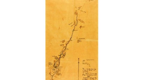
On the 4th November 2014, Sotheby’s London will offer for sale T.E. Lawrence’s hand-drawn map of northern Arabia, which records a pivotal moment in the history of the Arab Revolt against the Ottoman Empire. Charting his journey across the hostile desert in Saudi Arabia in May 1917, it is the only map in Lawrence’s hand detailing the route he followed in the days preceding the capture of the Red Sea port of Aqaba later that year, a victory which would prove decisive in the Arab uprising.
Recently shown in major exhibitions at the Imperial War Museum in London and at the Australian War Memorial Canberra*, the map is estimated to reach £70,000-100,000 at Sotheby’s London auction of Travel, Atlases, Maps and Natural History.
Pictured left: T.E Lawrence’s hand-drawn and annotated sketch map titled ‘Hejaz Railway to Wadi Sirhan’ detailing Lawrence’s traverse on 19-24 Map 1917, est. £70,000-100,000. Lawrence’s notebooks, now in the collection of the British Library, and worked up into the magnificent prose of Seven Pillars of Wisdom, provide a powerful evocation of this journey through harsh and pitiless land of Nefud desert.
The landscape challenged even a seasoned adventurer like Lawrence, with intense heat (“…Air streaming past as thick smoke with dust sun-blinking in it. Iridescent dusk…”) and blinding mudflats: “Sun reflects from them like mirror – flame-yellow, cutting into our eyes, like glare burning glass on closed lids. Head if veiled too hot: besides camel might stray … Heat in waves and eyes often going black.”
DRAWING THE MAP
Lawrence was well aware that his travels towards Aqaba had cartographical significance. Having met the explorer and cartographer Douglas Carruthers in the latter stages of the war, Lawrence created this map for him sometime between 1918 and 1922. Using his notebooks, he carefully plotted the map on a single sheet of tracing paper, signing it and annotating it with the words ‘This is the only drawn copy so please do not lose it prematurely’ [see detail, right].
In 1962, Carruthers donated the map to the Royal Society of Asian Affairs, in whose collection it has remained until now.
*Exhibited:
2005-2006: ‘Lawrence of Arabia – the life, the legend,’ Imperial War Museum, London
2007-2008: ‘Lawrence of Arabia and the Light Horse,’ Australian War Memorial, Canberra